Instruments
The 2.3-meter foam discus buoy
A circular foam hull with vertical sides that carries NOAA's SCOOP payload on a four-post tower. Of the moored buoys on Bluegraph, 4 use it, according to NDBC's station pages (October 2026), all on the Great Lakes: two in Lake Superior, one in Lake Erie and one in Lake Ontario. They are taken out of the water each winter.
- Hull
- Foam, 2.3 m across
- Deck
- About 0.7 m above the water
- Wind
- 3.6 m above the water
- Air temperature
- 3.3 m
- Pressure
- 2.3 m
- Water temperature
- 1.3 m below
- Reports
- Weather every 10 min, waves every 30
- Season
- Spring to fall, before the freeze
The buoy
Drag to rotate it; on a touch screen, move two fingers up or down to tilt it. Use Waves, Wind and Report to watch it work, and See-through to look inside the hull.
The sensors' heights follow NDBC's station pages. The hull above the water, the tower and the payload are estimated from NDBC's photograph of the buoy at sea, and so is the deck's height, scaled against those sensors. No source describes the rest, so it is assumed: the hull's shape under the water, drawn with a flat bottom; the well inside it and the position of the motion sensor; and the bridle, drawn like the 2.1-meter foam buoy's. The lake's waves are a 5-second sea and a 3-second chop, drawn at true scale. The hull rides them, rising and falling with the water at its center and tilting with its slope.
The hull
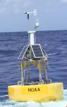
NDBC calls it a 2.3-meter foam discus buoy. NDBC's photograph of one at sea shows a yellow cylinder with vertical sides, rounded over at the top into a flat deck that stands roughly 0.7 m above the water. On the deck, four posts with lifting rings at their bases, and grab rails on two sides, rise to a square frame about 0.95 m up that carries the payload. We found no published drawing, weight or draft for this hull, and no description of the foam or of how the hull is built. The photograph shows nothing below the water.
We also found no explanation of why NDBC uses this hull at these four stations. Two other Great Lakes stations on Bluegraph, 45001 in Lake Superior and 45002 in Lake Michigan, use NDBC's 2.1-meter ionomer foam hull instead. In the Great Lakes, NDBC moors its buoys to pyramid-shaped anchors that it can recover.
The payload
The payload is SCOOP, NDBC's current payload, as on the 3-meter discus buoy: the electronics are in sealed modules, stacked into one unit. On this hull, the payload stands on the tower, higher than on the smaller foam buoy. Four solar panels lean around the electronics and batteries. On top, the weather tube holds the barometer at its base, 2.3 m above the water, and two masts. The taller one holds a propeller-vane anemometer, its propeller 3.6 m above the water. The shorter one holds an all-in-one sensor, 3.3 m up, that measures wind with sound, along with air temperature, humidity and pressure. The modules communicate with shore by Iridium satellite.
Waves
Nothing on the buoy measures the water's surface. A motion sensor in the payload's wave module records the hull's heave, pitch, roll and heading 1.7 times a second for 20 minutes, twice an hour, and NDBC treats the hull as following the surface. The processing is the same as the 3-meter discus buoy's: spectra in 46 bands from 0.0325 to 0.485 Hz (periods of about 31 s down to about 2 s), with direction from how the hull tilts as it rises and falls. The discus page explains how. Wave Intelligence separates the wave systems in these spectra. The position of the motion sensor in this hull isn't published, and we found no published comparison of this hull's wave measurements with a reference buoy.
The lakes' waves are wind sea. Their fetches (the distances the wind blows over open water) are too short for the long, low swell of the open ocean, and their waves are short: on Lake Superior, about 70% of sea states have periods of 3 to 5 seconds. In deep water, a wave's length grows with the square of its period, so a 5-second wave is about 39 m long, while an 8-second ocean swell is about 100 m long. At the same height, the lake's wave is two and a half times as steep. The frequency bands, which reach down to periods of about 2 s, cover the lakes' short waves. The figure's lake has a 5-second sea and a 3-second chop.
Wind, air and water
Wind is averaged over 10 minutes, six times an hour, and the gust is the highest 5-second mean in that time. The vane reads the direction relative to the hull, which turns freely on its mooring, and the buoy's compass converts that into a direction from north. NDBC publishes the wind as measured: 3.6 m up on this hull, compared with 3.2 m on the 2.1-meter foam buoy and 3.8 m on the 3-meter discus. That difference is worth knowing when comparing stations.
Air temperature and humidity are averaged over 10 minutes, and the dew point is calculated from them on shore. Pressure is measured in the weather tube, 2.3 m above the water, as a 1-minute mean, and corrected on shore for that height. Water temperature is measured 1.3 m below the waterline. Where its probe is mounted isn't published, so the figure puts it on the bridle.
The season
NDBC takes its Great Lakes buoys out of the water every year before the lakes freeze, along with their moorings and anchors, and puts them back in the same places the following spring. So these four report only during the open-water season, and their records on Bluegraph have a gap every winter.
The four are in very different water, according to their station pages: 45004, 70 nautical miles northeast of Marquette in eastern Lake Superior, in 237 m of water; 45006, 30 nautical miles northeast of Outer Island in western Lake Superior, in 195 m; 45012, 20 nautical miles north-northeast of Rochester in eastern Lake Ontario, in 143 m; and 45005, 16 nautical miles northwest of Lorain in western Lake Erie, in 9.8 m.
Reporting
Weather readings go to shore every 10 minutes and wave readings every 30 minutes, by Iridium satellite. On Bluegraph, a station on this hull reports wind speed, gust and direction; air temperature, dew point, pressure and its 3-hour change; water temperature; and wave height, periods and direction, with swell and wind sea shown separately, plus the directional spectra where the station sends them.
Sources
- NDBC station pages 45004, 45005, 45006 and 45012: the hull, the payload, the sensors' heights, the places and the water depths.
- NDBC, photograph of the 2.3-meter foam buoy: the hull above the water, the tower and the payload.
- NDBC, Programmatic environmental assessment for NDBC operations, 2018: the Great Lakes buoys' removal before the freeze and redeployment in spring, and their recoverable anchors.
- Great Lakes Observing System, metadata for 45006: "a 2.3 meter foam discus buoy that is seasonally deployed".
- Hall, Jensen and Wang, Performance evaluation of the newly operational NDBC 2.1-m hull, Journal of Atmospheric and Oceanic Technology 39(6), 2022: the Great Lakes' wind seas, without low-frequency swell for their short fetches.
- Bahr and Hill, Lake Superior as a suitable testing ground?, poster abstract, UMERC + METS 2024: about 70% of Lake Superior's sea states at periods of 3 to 5 seconds.
- National Weather Service, The SCOOP, 2023: the payload and reporting by Iridium.
- Teng, Bouchard, Riley and others, NDBC's Digital Directional Wave Module, OCEANS 2009: the motion sensor's sampling.
- NDBC, Handbook of automated data quality control checks and procedures, 2023: averaging and corrections on SCOOP buoys.